Deodhars in Kinnaur uncover centuries of climate change and growing geohazard risks in the Himalayas.
Deodar trees in Batseri, a village in the Sangla valley on the Baspa River in Himachal Pradesh, have revealed a story of shift from wetter spring conditions during Little Ice Age (LIA) to progressively drier spring conditions since after 1757 CE, with more spring drought years buried in recent decades.
The study analyses the factors responsible for the geohazard activities for the better prediction of future hazard events to support early warning systems.
The increasing frequency of extreme weather events, such as droughts and floods, and their link with geohazards like landslides, glacial lake outburst floods (GLOFs), rockfalls, and snow avalanches in the Himalayan region highlight the need for detailed reconstructions of past hydroclimatic variability and relate geohazards episodes.
Tree rings, which are layers of new wood that form each year, providing the record of the tree’s age and past environmental conditions act as natural archives to such climatic and geohazard events. This idea was further motivated by the absence of long-term high-resolution records and need to understand the interactions between moisture variability and geohazard activity in the Himalayas.
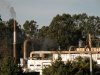
A rockfall event in July 2021 near Batseri in Kinnaur led the Birbal Sahni Institute of Palaeosciences (BSIP), under the Department of Science and Technology (DST), to study past climate conditions using dating of annual growth layers in trees (dendroclimatology and dendrogeomorphology). These methods were combined for future risk assessments and mitigation strategies.
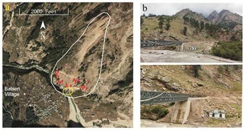
Tree-ring analysis of Deodar (Cedrus deodara) trees helped reconstruct a 378-year record (1558–2021 CE) spring moisture levels and a 168-year record (1853–2021 CE) of rockfall activity in Batseri, Kinnaur. The study showed that tree growth is highly sensitive to spring months (February to April), which is mainly influenced by winter precipitation from Western Disturbances.
A total of 53 rockfall events were identified, 8 of high-intensity, were linked to dry spring conditions, especially after year 1960, indicating climate-induced ground instability. The spring drought conditions led to slopes with poor vegetation cover, exposing them to vulnerability when the dry conditions are followed by the intense summer monsoon rainfalls.
The findings show that climate variability, particularly spring and pre-monsoon droughts is a major factor in triggering geohazards in the Himalayan region. The study enhanced the understanding by providing insights on how climate variability, trigger geohazards in the vulnerable Himalayan regions.
These findings can help local communities and policymakers in planning sustainable land use, improving forest and water resource management, and implementing slope-stability measures. This approach can reduce damage to infrastructure, protect livelihoods, enhance disaster preparedness. Moreover, such approach empowers communities to adapt to climate change and mitigate its impacts on their environment and economy.
What's Your Reaction?