
The Dharali flash flood of August 2025 devastated a Himalayan village, rerouting the Bhagirathi river and exposing critical vulnerabilities in Uttarakhand’s climate resilience, infrastructure, and disaster management. Advanced satellite imagery reveals new landscape challenges as authorities ramp up rescue and recovery.
A devastating flash flood struck Dharali village in Uttarkashi, Uttarakhand, on 5 August 2025, in what has emerged as one of the most severe high-altitude disasters in recent Indian memory. Triggered by intense rainfall and possibly aggravated by a cloudburst or glacial lake outburst, the event unleashed torrents of water and debris, transforming the local landscape, swallowing homes, roads, and the very course of the Bhagirathi river. As authorities, scientists, and communities reckon with the aftermath, this catastrophe highlights the mounting vulnerability of Himalayan settlements to extreme weather driven by climate change and human development patterns.
The disaster unfolded rapidly. Early afternoon, rains intensified across the upper Bhagirathi valley, and within minutes, a wall of mud-laden water tore through Dharali, a riverside village en route to the revered Gangotri Dham shrine. Satellite imagery from ISRO reveals the degree of destruction: areas mapped in June 2024—once dotted with orchards, cottages, and bridges—were, by 7 August, replaced by a massive debris field and deep inundation. The Kheer Gad river, a tributary joining the Bhagirathi, was obliterated—its banks lost beneath mudflows and sediment. About 20 hectares, formerly inhabited, now resemble a cratered wasteland.
Local accounts, corroborated by BBC and NDTV reports, describe the moment as terrifying and absolute. Residents and tourists had no chance to escape, with entire families stranded or buried. Dharali’s market, hotels, and clusters of homes vanished almost instantly. The incident struck not only civilians—Government sources confirmed that nine Army personnel are missing, while the Indo-Tibetan Border Police mobilised to rescue platoons cut off near the disaster’s edge. In the Barkot tehsil, livestock and commercial animals were swept away, deepening the impact on subsistence farmers.
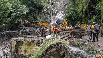
Rescue efforts were monumental but hampered by ongoing rainfall, poor visibility, and treacherous terrain. Within hours, the state government, Army’s Ibex Brigade, National Disaster Response Force (NDRF), and State Disaster Response Force (SDRF) began operations. With major bridges destroyed and roads erased, evacuation proceeded by helicopter and on foot, assisted by sniffer dogs and thermal sensors. At least 1,300 people were ultimately rescued in Dharali and surrounding villages, and restoration of “Valley Bridge” was prioritised to reconnect stranded populations.
Chief Minister Pushkar Singh Dhami ordered round-the-clock monitoring, updating the public and coordinating mobilisation of medical and material aid, food, and temporary shelter. The Union Home Minister and Prime Minister assured full assistance, including extra Army and police teams and air support, particularly as forecasts warned of more rain across northern Uttarakhand.
The acute impact is only part of the story. ISRO’s rapid satellite analysis, conducted by its Cartosat-2S platform, has proven vital in crisis mapping. By comparing pre- and post-flood imagery, scientists pinpointed the zones most affected, enabling rescuers to target resources efficiently. The scale and speed of landscape alteration have again raised major questions for policymakers about disaster resilience in mountainous terrain. Experts stress that such events—once deemed rare—are now increasingly likely due to a combination of warming-driven hydrological instability, glacial retreat, and infrastructure expansion that weakens natural buffers.
Damage assessment continues: at least 43 people, including Army personnel, are listed as missing; five deaths are confirmed but the toll may rise as debris is cleared and lists of missing Nepali workers, hotel staff, and villagers are updated. Essential services are disrupted, with supplies ferried in by emergency convoys. The initial restoration of roads and communication links restores a semblance of order, but long-term recovery will be complex—entailing psychological support, compensation for losses, and plans for resettlement.
Environmental implications loom large. Riverbank encroachment, high-density tourism development, and aggressive slope-cutting have all contributed to this increased risk. With the Bhagirathi river now routed through new channels, future floods are expected. ISRO’s data confirms massive sediment dumps, likely to reshape local hydrology for years. The valley’s capacity to absorb tourists, sustain agriculture, and maintain infrastructure must be reconsidered, according to district officials and geologists currently onsite.
In social terms, the flash flood has left many without homes or livelihoods, and numerous families face economic uncertainty for the next growing season. Local business owners—especially those operating hotels, shops, and orchards—have suffered near-total losses. The impact on religious tourism is immediate, with the Char Dham Yatra suspended while the Gangotri pilgrimage route is rehabilitated and landslide risk evaluated. The cultural fabric of this Himalayan hub has been deeply affected.
The 2025 Dharali flash flood forces a reckoning across agencies and levels of government. There are calls for a full scientific investigation into the event, with particular focus on the interplay between climate extremes, geomorphological changes, and human construction. Long-term adaptation may require stricter controls on development, upgraded disaster management planning, real-time satellite monitoring, and local community empowerment for early warning and evacuation.
Recent years have seen growing calls from parliamentary panels, disaster management authorities, and environmental experts for a national Himalayan resilience strategy, integrating risk mapping, predictive analytics, and multidimensional response capabilities. The Dharali tragedy stands as a harsh reminder that preparedness must be both scientific and socially inclusive, bridging local knowledge and state-of-the-art technology.
In summary, the August 2025 Dharali flash flood demonstrates the destructive force of Himalayan climate hazards. Yet, it also reveals the value of coordinated rescue, rapid satellite-based assessment, and the urgent need to adapt land-use, infrastructure, and economic models to the extreme new realities of high-mountain India. The state’s response offers hope, but the challenge remains: safeguarding lives and livelihoods in a rapidly changing environment.
What's Your Reaction?