Satellite analysis of Uttarakhand from 2001 to 2022 shows changing vegetation patterns linked to climate variability, pollution, and human activity, raising concerns over long-term ecosystem stability.
Satellite imagery of vegetation in the region, which encompasses the Himalayas, has indicated that vegetation in the region of Uttarakhand is displaying signs of sensitivity due to climate change, as seasonal changes in grasslands, forests, and in valleys in the region have been noted, as found in recent research.
The mountain ecosystem is considered vulnerable to climate variability. This is because changes in temperature and precipitation have an impact on the seasons of the plants. Changes in surface temperature and rain, for example, have an impact on plants.
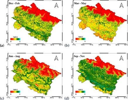
“Researchers from Aryabhatta Research Institute of Observational Sciences (ARIES), Nainital, an autonomous institution under Department of Science and Technology (DST), along with collaborators from India and other countries, employed satellite data to look for trends in vegetation cover in Uttarakhand State from 2001 to 2022 by using Google Earth Engine (GEE).”
The research used Normalized Difference Vegetation Index (NDVI), which is an extensively used metric for assessing vegetation density and health. Non-vegetated land cover types, such as rock, sand, water, exposed soil, and snow, are represented by low NDVI values, while dense vegetation types, including forests, croplands, and wetlands, are represented by higher NDVI values.
In addition to NDVI, the researchers processed and analyzed Enhanced Vegetation Index, and its correlation coefficients with climatic variables such as climatic variables such as temperature and rainfall have been investigated. In general, it is understood that the values of these vegetation indices remain high after the monsoon season and remain low before the monsoon season. However, there is a monthly, seasonal, and annual variation. It is understood that these natural climatic changes have now started to change over the past two decades.
An overall decrease in vegetation cover was also observed by the researchers, and it is related to factors such as deforestation, expansion of agricultural areas, illegal logging activities, and an increase in pollution levels from urban and industrial areas. The role of pollution, which is significant for plant growth, varies across different areas.
The study indicates that there are implications for biodiversity, water availability, and ecological stability in the Himalayan region with changes in patterns of vegetation. There are also possible implications for populations living downstream, which rely on resources from ecosystems within this region, such as water.
The results indicate that satellite monitoring can assist in identifying areas that are experiencing environmental stresses, which can be used to assess long-term changes.
What's Your Reaction?